We hope it's not for long.
Product Categories
- Bookends
- Curiosities
- Fashion
-
Fiction
- 19th Century and Prior Classics
- 20th Century Classics
- American Classics
- Anderson
- Antiquarian
- Arthurian Legends - Malory etc
- Atwood Margaret
- Australian Poetry
- Australian Rare
- Becke
- Biggles - Captain W.E. Johns
- Bronte Sisters
- Calder Erskine
- Carey Peter
- Chandler Raymond
- Childrens
- Christie Agatha
- Classics
- comedy and the like
- Conrad Joseph
- Courtenay Bryce
- Crime of the Fictional Variety
- Deco Period Collectables
- Defoe Daniel
- Dinesen Isak (Blixen Karen)
- Du Maurier - George
- du Maurier Daphne
- Erotic and exotic
- Fantasy
- Faulkner William
- Fictional Travel and Exploration
- Film and Theatre
- Fine Bindings
- First Edition or First of Type
- Fitzgerald, F Scott
- Fleming, Ian (James Bond 007)
- Forester C. S.
- French Language
- French Language or translation from or about the French
- Gibbs
- Gordon Richard
- Greek etc
- Greene Graham
- Hardy Frank
- Hemingway Ernest
- Herbert Xavier
- Humour
- Illustrated Works
- Le Carre John
- Lindsay Norman
- Louis
- May
- Mortimer
- Oppenhein E Phillips
- Romance to Remember
- Sherwood
- Spanish Classic or translation from Spanish
- Steinbeck John
- Stevenson Robert Louis
- Stow Randolph
- Swift Jonathan
- Tasmanian Fiction
- Tolkien J.R.R.
- Updike John
- Upfield Arthur
- Verne Jules
- Villiers Alan
- Wallace Edgar
- West Rebecca
- Wheatley Dennis
- White Patrick
- Williams Tennessee
- Wodeouse P.G.
- Latin
- Lawrence D.H.
- Charteris, Leslie - (The Saint)
- Lewis Sinclair
- Macleod
- Malouf David
- Maugham Somerset
- Monsarrat Nicholas
- Murdoch Iris
- Nobel Prize winning Authors
- O'Harris Pixie
- Pictorial Covers
- Poetry and Plays and Music Scores
- Private Press
- Rider Haggard H.
- Science Fiction
- Simenon Georges
- Southall Ivan
- Manuscripts
- Maps
- Medals
- Minerals
- Mortimer John (Rumploe)
-
Non-fiction
- Aboriginal
- Africa
- Agriculture
- Ancient History / Classics
- Antarctic, Arctic, Polar
- Anthropology
- Antiquarian
- Archaeology
- Architecture
- Art
- Asia
- Astronomy
- Australian Coastal Exploration and Maritime
- Australian Inland Exploration
- Australiana
- Aviation Including Airships
- Banking and Commerce
- Biography/ autobiography
- Books on books
- Bounty / Pitcairn
- Business
- Canada
- Cartography
- Chess, Cards, Boards Games etc
- Classical History
- Convicts, transporation etc
- Cook, James
- Cookery and other delights
- Crime of the True Variety
- Dutch Exploration and other things Dutch
- Economics and Business Affairs
- Egypt
- Engineering
- English History
- Esoteric
- Espionage
- Exploration
- Fine Bindings
- Fishing
- French Language translations or about the French
- Heraldry
- Horology / watch and clock history
- Horses
- Idriess, Ion
- Ilustrated
- India
- Japan
- Law
- Lawrence of Arabia
- Literature (Go to Fiction)
- Maritime
- Medical, Medical History and Medical Science
- Middle East
- Military and Naval - pre 20th Century
- Mining and Geology
- Mountaineering
- Music
- Natural History
- Naval - Military
- Naval - Military - Pre-20th Century
- New South Wales
- New Zealand
- Norfolk Island
- North America
- Northern Territory
- Pacific Islands
- Papua New Guinea
- Politics
- Queensland
- Railways
- Religion
- Royal Geographical Society Journals and Similar Journals
- Science Fiction (See Literature)
- Science including Natural Sciences, Chemistry, Physics, Mathematics, Astronomy, Medical Sciences etc
- Scotland
- Shipwrecks
- South America
- South Australia
- Spiritualism , Mesmerism, Psychical Reseach
- Sport - Including Horse Racing, Cricket , Rugby, Game Sports etc
- Surveying
- Tasmania and Van Diemens Land
- Travel & Voyages
- United States of America
- Victoria
- War & Escape - 20th Century
- Western Australia
- Yachting
- Royal Geographical Society Journals
- Maritime
- Mining/Geology
- Prestige Items
-
Prints and Photographs and Bookplates
- Architecture
- Australian Botanicals
- Australian Views
- Birds including Australian Birds
- Book-Plates
- Botanicals
- Cigarette and Trade Cards
- Cricket
- Egyptian
- Erotic / Classical
- French Fashion
- Great Exploratory Voyages
- Medical
- Military and Military Uniform
- Natural History
- Photographs
- Rare Postage Stamps
- Rugby etc
- Sports - Racing
- Queensland
- Scientific Instruments, Specimens, Books and Collectables
- Tasmania
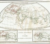
Systemes Geographiques de Ptoloemee, de Strabon et d’Eratosthene – Malte Brun c1826
Short Description
Original engraved map from Malte Brun’s Atlas of the Ancient Greek geographers Ptolemy, Strabo and Eratosthenes. The then known World.
32cm by 24cm partially coloured in outline. A good example on strong wove paper, the odd mark around the bottom border, generally clean and bright.
Conrad Malte Brun (1755-1826) a major Danish born cartographer who worked out of France during his professional life. This example was drawn by Bovinel Giraldon and engrave by Jean Baptiste Marie Chamouin, individuals who worked for Malte Brun early in the 19th Century. After his death his son went on publishing the maps for a number of years making the precise year in which the map was made difficult to determine.
The Ptolemy map takes pride of place, being regarded as more accurate and informative. We particularly like the naming of Sri Lanka as Taprobana a matter that has been disputed in some cartographic quarters.
The island of Thule appears on the Eratosthenes map ... an unsolved mystery. Some think it was Ireland or the Shetlands or an island off Norway. Unfortunately the Nazi's spoilt the mystery somewhat by claiming it was the birthplace of their superior race.
Price $90.00 unframed ....
The World as it was thought to be by the Greek scholars.
 Updating...

