We hope it's not for long.
Product Categories
- Bookends
- Curiosities
- Fashion
-
Fiction
- 19th Century and Prior Classics
- 20th Century Classics
- Antiquarian
- Arthurian Legends - Malory etc
- Australian Rare
- Becke
- Biggles - Captain W.E. Johns
- Carey Peter
- Chandler Raymond
- Childrens
- Christie Agatha
- Classics
- comedy and the like
- Conrad Joseph
- Crime of the Fictional Variety
- Deco Period Collectables
- Defoe Daniel
- Dinesen Isak (Blixen Karen)
- Du Maurier - George
- du Maurier Daphne
- Erotic and exotic
- Fantasy
- Faulkner William
- Fictional Travel and Exploration
- Film and Theatre
- Fine Bindings
- First Edition or First of Type
- Fitzgerald, F Scott
- Fleming, Ian (James Bond 007)
- Forester C. S.
- French Language
- French Language or translation from or about the French
- Gibbs
- Gordon Richard
- Greek etc
- Greene Graham
- Hardy Frank
- Hemingway Ernest
- Herbert Xavier
- Humour
- Idriess
- Illustrated Works
- Ion
- John (Rumpole)
- Lindsay Norman
- Louis
- May
- Mortimer
- Spanish Classic or translation from Spanish
- Steinbeck John
- Stevenson Robert Louis
- Stow Randolph
- Swift Jonathan
- Tolkien J.R.R.
- Updike John
- Upfield Arthur
- Ustinov Peter
- Verne Jules
- Villiers Alan
- Wallace Edgar
- West Rebecca
- White Patrick
- Williams Tennessee
- Wodeouse P.G.
- Latin
- Lawrence D.H.
- Charteris, Leslie - (The Saint)
- Lewis Sinclair
- Macleod
- Malouf David
- Maugham Somerset
- Monsarrat Nicholas
- Murdoch Iris
- Nobel Prize winning Authors
- O'Harris Pixie
- Pictorial Covers
- Poetry and Plays and Music Scores
- Private Press
- Rider Haggard H.
- Science Fiction
- Simenon Georges
- Southall Ivan
- Manuscripts
- Maps
- Medals
- Mortimer John (Rumploe)
-
Non-fiction
- Aboriginal
- Africa
- Agriculture
- Ancient History / Classics
- Antarctic, Arctic, Polar
- Anthropology
- Antiquarian
- Archaeology
- Architecture
- Art
- Arthurian Legends - Malory etc
- Asia
- Astronomy
- Australian Coastal Exploration and Maritime
- Australian Inland Exploration
- Australiana
- Aviation Including Airships
- Banking and Commerce
- Biography/ autobiography
- Books on books
- Bounty / Pitcairn
- Business
- Cartography
- Chess, Cards, Boards Games etc
- Classical History
- Climate Change
- Convicts, transporation etc
- Cook, James
- Cookery and other delights
- Crime of the True Variety
- Cycling
- Dutch Exploration and other things Dutch
- Economics and Business Affairs
- Egypt
- Engineering
- English History
- Esoteric
- Espionage
- Exploration
- Fine Bindings
- Fishing
- French Language translations or about the French
- Heraldry
- Horology / watch and clock history
- Horses
- Idriess, Ion
- Ilustrated
- India
- Japan
- Law
- Lawrence of Arabia
- Literature (Go to Fiction)
- Maritime
- Medical, Medical History and Medical Science
- Middle East
- Military and Naval - pre 20th Century
- Mining and Geology
- Mountaineering
- Music
- Natural History
- Naval - Military
- Naval - Military - Pre-20th Century
- New South Wales
- New Zealand
- Norfolk Island
- North America
- Northern Territory
- Pacific Islands
- Papua New Guinea
- Politics
- Queensland
- Railways
- Religion
- Royal Geographical Society Journals and Similar Journals
- Science Fiction (See Literature)
- Science including Natural Sciences, Chemistry, Physics, Mathematics, Astronomy, Medical Sciences etc
- Scotland
- Shipwrecks
- South America
- South Australia
- Spiritualism , Mesmerism, Psychical Reseach
- Sport - Including Horse Racing, Cricket , Rugby, Game Sports etc
- Surveying
- Tasmania and Van Diemens Land
- Travel & Voyages
- United States of America
- Victoria
- War & Escape - 20th Century
- Western Australia
- Yachting
- Royal Geographical Society Journals
- Maritime
- Mining/Geology
- Prestige Items
-
Prints and Photographs and Bookplates
- Architecture
- Australian Botanicals
- Australian Views
- Birds including Australian Birds
- Book-Plates
- Botanicals
- Cigarette and Trade Cards
- Cricket
- Egyptian
- Erotic / Classical
- French Fashion
- Great Exploratory Voyages
- Medical
- Military and Military Uniform
- Natural History
- Photographs
- Rare Postage Stamps
- Rugby etc
- Sports - Racing
- Queensland
- Scientific Instruments, Specimens, Books and Collectables
- Tasmania
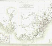
Part of Australia comprising the settled portions of New South Wales and South Australia. – William Hughes – 1844
Short Description
A fine example of Adam and Charles Black’s 1844 map which pre-dated the formation of Victoria in 1851 so here is referred to as Australia Felix. The inset map shows Norfolk Island. The coastline to the East extends past Moreton Island and to the West to Point Fowler. The interior is still sparsely understood and the extent of Lake Torrens is perhaps greatly exaggerated. Twenty Counties of New South wales are outlined in colour and a key is shown in the bottom right. Relief is shown by hachure.
Included in the National Library Collection, cited in Tooley’s dictionary of mapmakers 142. Dimensions 36.7 by 25.3 cm.
Charles and uncle Adam Black founded their publishing firm in 1807. Their publications included the Encyclopaedia Britannica and incidentally Walter Scott’s novels.
William Hughes (1818-1876) was a cartographer active in London during the middle part of the 19th century. He was elected a Fellow of the Royal Geographical Society in 1838 and from 1840 taught cartography at a number of distinguished institutions and was also the map librarian at the British Museum.
A good copy of a detailed map from an important era ... Click on the map to see its entirety ... ask if you require more images
 Updating...

