We hope it's not for long.
Product Categories
- Bookends
- Curiosities
- Fashion
-
Fiction
- 19th Century and Prior Classics
- 20th Century Classics
- American Classics
- Anderson
- Antiquarian
- Arthurian Legends - Malory etc
- Atwood Margaret
- Australian Poetry
- Australian Rare
- Becke
- Biggles - Captain W.E. Johns
- Bronte Sisters
- Calder Erskine
- Carey Peter
- Chandler Raymond
- Childrens
- Christie Agatha
- Classics
- comedy and the like
- Conrad Joseph
- Courtenay Bryce
- Crime of the Fictional Variety
- Deco Period Collectables
- Defoe Daniel
- Dinesen Isak (Blixen Karen)
- Du Maurier - George
- du Maurier Daphne
- Erotic and exotic
- Fantasy
- Faulkner William
- Fictional Travel and Exploration
- Film and Theatre
- Fine Bindings
- First Edition or First of Type
- Fitzgerald, F Scott
- Fleming, Ian (James Bond 007)
- Forester C. S.
- French Language
- French Language or translation from or about the French
- Gibbs
- Gordon Richard
- Greek etc
- Greene Graham
- Hardy Frank
- Hemingway Ernest
- Herbert Xavier
- Humour
- Illustrated Works
- Le Carre John
- Lindsay Norman
- Louis
- May
- Mortimer
- Oppenhein E Phillips
- Romance to Remember
- Sherwood
- Spanish Classic or translation from Spanish
- Steinbeck John
- Stevenson Robert Louis
- Stow Randolph
- Swift Jonathan
- Tasmanian Fiction
- Tolkien J.R.R.
- Updike John
- Upfield Arthur
- Verne Jules
- Villiers Alan
- Wallace Edgar
- West Rebecca
- Wheatley Dennis
- White Patrick
- Williams Tennessee
- Wodeouse P.G.
- Latin
- Lawrence D.H.
- Charteris, Leslie - (The Saint)
- Lewis Sinclair
- Macleod
- Malouf David
- Maugham Somerset
- Monsarrat Nicholas
- Murdoch Iris
- Nobel Prize winning Authors
- O'Harris Pixie
- Pictorial Covers
- Poetry and Plays and Music Scores
- Private Press
- Rider Haggard H.
- Science Fiction
- Simenon Georges
- Southall Ivan
- Manuscripts
- Maps
- Medals
- Minerals
- Mortimer John (Rumploe)
-
Non-fiction
- Aboriginal
- Africa
- Agriculture
- Ancient History / Classics
- Antarctic, Arctic, Polar
- Anthropology
- Antiquarian
- Archaeology
- Architecture
- Art
- Asia
- Astronomy
- Australian Coastal Exploration and Maritime
- Australian Inland Exploration
- Australiana
- Aviation Including Airships
- Banking and Commerce
- Biography/ autobiography
- Books on books
- Bounty / Pitcairn
- Business
- Canada
- Cartography
- Chess, Cards, Boards Games etc
- Classical History
- Convicts, transporation etc
- Cook, James
- Cookery and other delights
- Crime of the True Variety
- Dutch Exploration and other things Dutch
- Economics and Business Affairs
- Egypt
- Engineering
- English History
- Esoteric
- Espionage
- Exploration
- Fine Bindings
- Fishing
- French Language translations or about the French
- Heraldry
- Horology / watch and clock history
- Horses
- Idriess, Ion
- Ilustrated
- India
- Japan
- Law
- Lawrence of Arabia
- Literature (Go to Fiction)
- Maritime
- Medical, Medical History and Medical Science
- Middle East
- Military and Naval - pre 20th Century
- Mining and Geology
- Mountaineering
- Music
- Natural History
- Naval - Military
- Naval - Military - Pre-20th Century
- New South Wales
- New Zealand
- Norfolk Island
- North America
- Northern Territory
- Pacific Islands
- Papua New Guinea
- Politics
- Queensland
- Railways
- Religion
- Royal Geographical Society Journals and Similar Journals
- Science Fiction (See Literature)
- Science including Natural Sciences, Chemistry, Physics, Mathematics, Astronomy, Medical Sciences etc
- Scotland
- Shipwrecks
- South America
- South Australia
- Spain
- Spiritualism , Mesmerism, Psychical Reseach
- Sport - Including Horse Racing, Cricket , Rugby, Game Sports etc
- Surveying
- Tasmania and Van Diemens Land
- Travel & Voyages
- United States of America
- Victoria
- War & Escape - 20th Century
- Western Australia
- Yachting
- Royal Geographical Society Journals
- Maritime
- Mining/Geology
- Prestige Items
-
Prints and Photographs and Bookplates
- Architecture
- Australian Botanicals
- Australian Views
- Birds including Australian Birds
- Book-Plates
- Botanicals
- Cigarette and Trade Cards
- Cricket
- Egyptian
- Erotic / Classical
- French Fashion
- Great Exploratory Voyages
- Medical
- Military and Military Uniform
- Natural History
- Photographs
- Rare Postage Stamps
- Rugby etc
- Sports - Racing
- Queensland
- Scientific Instruments, Specimens, Books and Collectables
- Tasmania
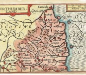
Map of Northumberland – John Speed / Pieter van den Keere – 1627
Short Description
A delightful and quite rare map of Northumberland … the origin of Voyager.
Pieter van den Keere (1571-1646) engraved a series of miniature English County maps based on the original surveys of Christopher Saxton. First published by Willem Janzoon Blaeu in 1617 they were Anglicised by the great cartographer John Speed and published by George Humble in 1627. They are often referred to as “Miniature Speeds".
Printed area 12.3cm by 8.6cm good plate mark. This example has a shallow lower margin and a little age … altogether still a very good example of a rare near 400 year old map.
The map stretches to Carlisle and beyond in Cumberland. The county border is clearly shown as a dotted line and at this time Berwick – Upon – Tweed (Barwick) is clearly in England. Holy Island, the Farnes and Coquet Island feature in their olde names. The Cheviot and Simonside Hills are shown and numerous of the Northumberland Norman Castles feature. Interestingly, Cartington has been mis-engraved and a little “t” has been inserted above … a distinctive feature of this engraving that pins its provenance down quite nicely. Voyager used to play among the ruins of Cartington as a young fellow.
Special map of Northumberland a delight for expatriate Northumbrians and all.
 Updating...

