We hope it's not for long.
Product Categories
- Bookends
- Curiosities
- Fashion
-
Fiction
- 19th Century and Prior Classics
- 20th Century Classics
- Antiquarian
- Arthurian Legends - Malory etc
- Australian Rare
- Becke
- Biggles - Captain W.E. Johns
- Carey Peter
- Chandler Raymond
- Childrens
- Christie Agatha
- Classics
- comedy and the like
- Conrad Joseph
- Crime of the Fictional Variety
- Deco Period Collectables
- Defoe Daniel
- Dinesen Isak (Blixen Karen)
- Du Maurier - George
- du Maurier Daphne
- Erotic and exotic
- Fantasy
- Faulkner William
- Fictional Travel and Exploration
- Film and Theatre
- Fine Bindings
- First Edition or First of Type
- Fitzgerald, F Scott
- Fleming, Ian (James Bond 007)
- Forester C. S.
- French Language
- French Language or translation from or about the French
- Gibbs
- Gordon Richard
- Greek etc
- Greene Graham
- Hardy Frank
- Hemingway Ernest
- Herbert Xavier
- Humour
- Idriess
- Illustrated Works
- Ion
- John (Rumpole)
- Lindsay Norman
- Louis
- May
- Mortimer
- Spanish Classic or translation from Spanish
- Steinbeck John
- Stevenson Robert Louis
- Stow Randolph
- Swift Jonathan
- Tolkien J.R.R.
- Updike John
- Upfield Arthur
- Ustinov Peter
- Verne Jules
- Villiers Alan
- Wallace Edgar
- West Rebecca
- White Patrick
- Williams Tennessee
- Wodeouse P.G.
- Latin
- Lawrence D.H.
- Charteris, Leslie - (The Saint)
- Lewis Sinclair
- Macleod
- Malouf David
- Maugham Somerset
- Monsarrat Nicholas
- Murdoch Iris
- Nobel Prize winning Authors
- O'Harris Pixie
- Pictorial Covers
- Poetry and Plays and Music Scores
- Private Press
- Rider Haggard H.
- Science Fiction
- Simenon Georges
- Southall Ivan
- Manuscripts
- Maps
- Medals
- Mortimer John (Rumploe)
-
Non-fiction
- Aboriginal
- Africa
- Agriculture
- Ancient History / Classics
- Antarctic, Arctic, Polar
- Anthropology
- Antiquarian
- Archaeology
- Architecture
- Art
- Arthurian Legends - Malory etc
- Asia
- Astronomy
- Australian Coastal Exploration and Maritime
- Australian Inland Exploration
- Australiana
- Aviation Including Airships
- Banking and Commerce
- Biography/ autobiography
- Books on books
- Bounty / Pitcairn
- Business
- Cartography
- Chess, Cards, Boards Games etc
- Classical History
- Climate Change
- Convicts, transporation etc
- Cook, James
- Cookery and other delights
- Crime of the True Variety
- Cycling
- Dutch Exploration and other things Dutch
- Economics and Business Affairs
- Egypt
- Engineering
- English History
- Esoteric
- Espionage
- Exploration
- Fine Bindings
- Fishing
- French Language translations or about the French
- Heraldry
- Horology / watch and clock history
- Horses
- Idriess, Ion
- Ilustrated
- India
- Japan
- Law
- Lawrence of Arabia
- Literature (Go to Fiction)
- Maritime
- Medical, Medical History and Medical Science
- Middle East
- Military and Naval - pre 20th Century
- Mining and Geology
- Mountaineering
- Music
- Natural History
- Naval - Military
- Naval - Military - Pre-20th Century
- New South Wales
- New Zealand
- Norfolk Island
- North America
- Northern Territory
- Pacific Islands
- Papua New Guinea
- Politics
- Queensland
- Railways
- Religion
- Royal Geographical Society Journals and Similar Journals
- Science Fiction (See Literature)
- Science including Natural Sciences, Chemistry, Physics, Mathematics, Astronomy, Medical Sciences etc
- Scotland
- Shipwrecks
- South America
- South Australia
- Spiritualism , Mesmerism, Psychical Reseach
- Sport - Including Horse Racing, Cricket , Rugby, Game Sports etc
- Surveying
- Tasmania and Van Diemens Land
- Travel & Voyages
- United States of America
- Victoria
- War & Escape - 20th Century
- Western Australia
- Yachting
- Royal Geographical Society Journals
- Maritime
- Mining/Geology
- Prestige Items
-
Prints and Photographs and Bookplates
- Architecture
- Australian Botanicals
- Australian Views
- Birds including Australian Birds
- Book-Plates
- Botanicals
- Cigarette and Trade Cards
- Cricket
- Egyptian
- Erotic / Classical
- French Fashion
- Great Exploratory Voyages
- Medical
- Military and Military Uniform
- Natural History
- Photographs
- Rare Postage Stamps
- Rugby etc
- Sports - Racing
- Queensland
- Scientific Instruments, Specimens, Books and Collectables
- Tasmania
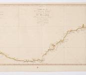
Original Chart of New South Wales or the East Coast of New Holland, discovered by Lieutenant James Cook, Commander of H.M. Bark, Endeavour -1770
Short Description
The French version – “Carte de la Nle. Galles Meridle. ou de la cote orientale de la Nle. Hollande, decouverte et visitee par le Lieutenant J. Cook, Commandant de L’Endeavour, vassieu de sa Majeste en 1770
Original copperplate engraving by distinguished cartographer Robert Benard recording Cook’s navigational records, published in Paris circa 1774. Large format 77cm by 36cm, original folds, coloured in outline.
On his first of three voyages James Cook discovered and charted the East Coast of Australia for the first time and this chart resulted from that work. There are many interesting features including Mt Warning, the Glass House Mountains (named as such because they reminded Cook of the view of the coastal Glass Kilns as seen from the water in the South West of England) and the record of the grounding on the reef of Cape Tribulation before recovering the vessel in the Endeavour River in the Far North.
Price $890.00 unframed
James Cook’s Chart of New South Wales
 Updating...

