We hope it's not for long.
Product Categories
- Bookends
- Curiosities
- Fashion
-
Fiction
- 19th Century and Prior Classics
- 20th Century Classics
- American Classics
- Anderson
- Antiquarian
- Arthurian Legends - Malory etc
- Atwood Margaret
- Australian Poetry
- Australian Rare
- Becke
- Biggles - Captain W.E. Johns
- Bronte Sisters
- Calder Erskine
- Carey Peter
- Chandler Raymond
- Childrens
- Christie Agatha
- Classics
- comedy and the like
- Conrad Joseph
- Courtenay Bryce
- Crime of the Fictional Variety
- Deco Period Collectables
- Defoe Daniel
- Dinesen Isak (Blixen Karen)
- Du Maurier - George
- du Maurier Daphne
- Erotic and exotic
- Fantasy
- Faulkner William
- Fictional Travel and Exploration
- Film and Theatre
- Fine Bindings
- First Edition or First of Type
- Fitzgerald, F Scott
- Fleming, Ian (James Bond 007)
- Forester C. S.
- French Language
- French Language or translation from or about the French
- Gibbs
- Gordon Richard
- Greek etc
- Greene Graham
- Hardy Frank
- Hemingway Ernest
- Herbert Xavier
- Humour
- Illustrated Works
- Le Carre John
- Lindsay Norman
- Louis
- May
- Mortimer
- Oppenhein E Phillips
- Romance to Remember
- Sherwood
- Shute Nevil
- Spanish Classic or translation from Spanish
- Steinbeck John
- Stevenson Robert Louis
- Stow Randolph
- Swift Jonathan
- Tasmanian Fiction
- Tolkien J.R.R.
- Updike John
- Upfield Arthur
- Verne Jules
- Villiers Alan
- Wallace Edgar
- West Rebecca
- Wheatley Dennis
- White Patrick
- Williams Tennessee
- Wodeouse P.G.
- Latin
- Lawrence D.H.
- Charteris, Leslie - (The Saint)
- Lewis Sinclair
- Macleod
- Malouf David
- Maugham Somerset
- Monsarrat Nicholas
- Murdoch Iris
- Nobel Prize winning Authors
- O'Harris Pixie
- Pictorial Covers
- Poetry and Plays and Music Scores
- Private Press
- Rider Haggard H.
- Science Fiction
- Simenon Georges
- Southall Ivan
- Manuscripts
- Maps
- Medals
- Minerals
- Mortimer John (Rumploe)
-
Non-fiction
- Aboriginal
- Africa
- Agriculture
- Ancient History / Classics
- Antarctic, Arctic, Polar
- Anthropology
- Antiquarian
- Archaeology
- Architecture
- Art
- Asia
- Astronomy
- Australian Coastal Exploration and Maritime
- Australian Inland Exploration
- Australiana
- Aviation Including Airships
- Banking and Commerce
- Biography/ autobiography
- Books on books
- Bounty / Pitcairn
- Business
- Canada
- Cartography
- Chess, Cards, Boards Games etc
- Classical History
- Convicts, transporation etc
- Cook, James
- Cookery and other delights
- Crime of the True Variety
- Dutch Exploration and other things Dutch
- Economics and Business Affairs
- Egypt
- Engineering
- English History
- Esoteric
- Espionage
- Exploration
- Fine Bindings
- Fishing
- French Language translations or about the French
- Heraldry
- Horology / watch and clock history
- Horses
- Idriess, Ion
- Ilustrated
- India
- Japan
- Law
- Lawrence of Arabia
- Literature (Go to Fiction)
- Maritime
- Medical, Medical History and Medical Science
- Middle East
- Military and Naval - pre 20th Century
- Mining and Geology
- Mountaineering
- Music
- Natural History
- Naval - Military
- Naval - Military - Pre-20th Century
- New South Wales
- New Zealand
- Norfolk Island
- North America
- Northern Territory
- Pacific Islands
- Papua New Guinea
- Politics
- Queensland
- Railways
- Religion
- Royal Geographical Society Journals and Similar Journals
- Science Fiction (See Literature)
- Science including Natural Sciences, Chemistry, Physics, Mathematics, Astronomy, Medical Sciences etc
- Scotland
- Shipwrecks
- South America
- South Australia
- Spain
- Spiritualism , Mesmerism, Psychical Reseach
- Sport - Including Horse Racing, Cricket , Rugby, Game Sports etc
- Surveying
- Tasmania and Van Diemens Land
- Travel & Voyages
- United States of America
- Victoria
- War & Escape - 20th Century
- Western Australia
- Yachting
- Royal Geographical Society Journals
- Maritime
- Mining/Geology
- Prestige Items
-
Prints and Photographs and Bookplates
- Architecture
- Australian Botanicals
- Australian Views
- Birds including Australian Birds
- Book-Plates
- Botanicals
- Cigarette and Trade Cards
- Cricket
- Egyptian
- Erotic / Classical
- French Fashion
- Great Exploratory Voyages
- Medical
- Military and Military Uniform
- Natural History
- Photographs
- Rare Postage Stamps
- Rugby etc
- Sports - Racing
- Queensland
- Scientific Instruments, Specimens, Books and Collectables
- Tasmania
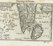
Narzinge and Ceylon Petrus Bertius – Published 1610
Short Description
An original copper engraved miniature map of Southern India and Sri Lanka (Ceylon). One of the earliest maps of the region.
This map was originally drawn by Barent Langenes and published by him at Middleburg and as part of Petrus Bertius’ Caert-Thresoor in 1598.
Bertius continued to include this map in his most successful “Tabularum Geographicarum Contractarum Libri” published by Cornelis Claesz in Amsterdam. This example comes from the 1603 edition of “Tabularum”.
It is rather scarce. Here uncoloured, as it should be 85mm by 122mm. Very good condition, any darkening of the paper exaggerated by the scan.
Petrus Bertius (1565-1629) was born the son of a Flemish minister a Baveren, Flanders. He became a religious refugee and moved and settled in Amsterdam. In 1577. After finishing his studies he was appointed Professor of Mathematics at the University of Leiden. He became a prolific writer on mathematics, history and theology. He also gained renown as a geographer and publisher of magnificent atlases. Later in life, in 1618 he became cosmographer and historiographer to Louis XIII of France. He died in Paris in 1629
Price as unframed
 Updating...

