0
There are no products in your shopping cart!
We hope it's not for long.
We hope it's not for long.
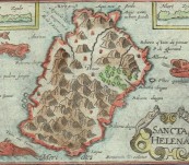
One of the most striking and coveted island maps from the early 17th Century – Saint Helena in the South Atlantic home for Napoleon after his second capture.
Engraved by Benjamin Wright for the great geographer Petrus Bertius and published by Cornelis Claesz in Amsterdam in 1603 for the “Tabularum Geographicarum Contractarum Libri”
Distinctively signed by the elusive Wright in his abbreviated fashion near the bottom center of the plate.
Map 12cm by 9cm to the printed borders. A Voyager favourite.
Price framed in Voyager Miniature map style in beaded gilt frame with gilt fillet. Enquire if you wish it unframed.
 Updating...

